In short:
The impacts of ex-Tropical Cyclone Alfred are still being felt along Australia’s east coast with creek rises and flash flooding hitting some regions.
Queensland SES received a record number of calls overnight as attention shifts to the Lockyer Valley.
In NSW, a number of rivers are have flood watch warnings.
Dozens of people were rescued overnight in Queensland as the State Emergency Service (SES) fielded 3,600 calls, a record.
Heavy rainfall has also cut the Warrego Highway, a major road connecting Brisbane and Toowoomba.
The Queensland State Emergency Service rescued dozens of people overnight.(ABC News: Brendan Esposito)
Queensland Premier David Crisafulli said the impacts were far-reaching across the state, but the Lockyer Valley area was a particular concern.
“A very serious storm cell is moving in that area and overnight, there were doorknocks in areas like Laidley and Grantham — two communities that are no strangers to flooding,” he told reporters on Monday.
Laidley Creek could see January 2011 flood levels of 8.85 millimetres, according to the Bureau of Meteorology (BOM).
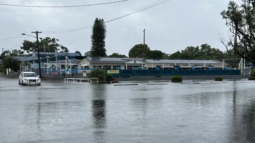
Mr. Crisafulli said it had also been a “very difficult 24 hours for Hervey Bay” and the scale of the damage was expected to be “significant”.
About 200mm of rain fell within 2 hours early on Sunday morning, sparking widespread flash flooding.
Hervey Bay Hospital remains open, but some supermarkets have been inundated, disrupting the food supply.
The Queensland Fire Department said 35 people were rescued during the night, from the Sunshine Coastdown to the border and west to the Lockyer Valley.
As of Monday afternoon, major flood warnings are current for Lockyer and Laidley creeks, the Bremer River, Warrill Creek and Logan and Albert Rivers.
A moderate flood warning is active for the Stanley River, while minor flood warnings are current for the Upper Brisbane River and Brisbane River downstream of Wivenhoe Dam.
Flood threat receding in parts of NSW
South of the border, there are 23 emergency warnings covering 10,200 people across the Northern Rivers and Mid North Coast regions, according to the NSW SES.
The main concern for the region is still floodwater, with the Clarence River near Grafton — which peaked at 5.7 metres last night — the Tweed River at Tumbulgum, the Richmond River at Coraki and Bungawalbyn all with major warnings as of 12:30pm this afternoon.
But while some of the state’s northern rivers are rising, others are now beginning to recede.
According to the Bureau of Meteorology (BOM), moderate flooding is continuing in the Wilson River at Lismore, but levels are dropping.
Some rivers across northern NSW are still rising but others have started to recede.(ABC News: Victoria Pengilley)
More than 200,000 homes are without power in Queensland, while roughly 9,800 homes and businesses are still without electricity in NSW.
Schools in the impacted NSW region have been closed since Friday but are expected to reopen on Tuesday.
In Queensland, 463 state schools, and 259 independent and Catholic schools, are shut.
Airports on the Sunshine Coast, Brisbane, Gold Coast, and Toowoomba’s Wellcamp are open, and flights are resuming.
What’s to come?
Queensland will continue to be lashed with very heavy rainfall leading to dangerous and life-threatening flash flooding, according to Sue Oates from the BOM.
She said the bureau was tracking thunderstorms around the Cherbourg, Somerset and Lockyer Valley council regions this morning, which were producing 50mm of rainfall an hour.
The weather bureau is predicting that Queensland will continue to be hit with heavy rainfall.(Supplied: Tegan Maskell)
Ms Oates said the bureau saw totals of up to 140mm in 3 hours in those storms, but conditions had eased.
While storms have lessened, the risk is continuing.
“We have issued a severe weather warning for south-east, extending from the north of Gym down to the Queensland border and westward to include areas of Toowoomba and out to Goiwindi.“ she said.
“Typically, 6-hour rain totals are expected to be in the range of 80 to 120mm but totals up to 150mm in a 6-hour period is not out of the question.”